Hi-Tech
Remote sensing, Photogrammetry and LIDAR
From remote sensing we obtain information about objects and phenomena using aerial or satellite images, without the need for physical contact with the surface.
Using photogrammetry, we acquire information about physical objects and environments through the process of recording, measuring and interpreting photographic images, images and patterns of electromagnetic radiation and other phenomena.
What can be done with satellite or aerial imagery?
- rectification and orthorectification of aerial and satellite images
- Geometric, radiometric corrections, mosaicking, including colour matching (eg in documentary and interpretive work, conservation)
- classification (multispectral, textural, sub-pixel, multitemporal), detection of surface types, highlighting of selected objects and phenomena in the image, mapping in combination with terrestrial data collection methods
- vegetation indices
- Combining images with different resolutions
- creation of aerial and satellite maps
- DEM calculation from stereo image (3D relief model)
- Raster format conversion
- relief analysis (gradients, orientation, visibility, height profiles)
- creation of 3D models, visualisation, simulation of overflight (VirtualGIS)
- creation and updating of thematic layers of GIS based on aerial and satellite images and other processing according to your requirements in combination with LIDAR and other materials using GIS and CAD tools.
Use:
- mapping
- environmental studies / forestry
- crisis management, eg. monitoring of fires, floods, hurricane consequences
- geology
- meteorology
- agriculture (eg. control of agricultural subsidies)
- hydrology, digital terrain models, runoff studies
- cubature calculation


If you are interested in learning more about Photogrammetry, please contact our experienced sales representatives who will be happy to tell you more and prepare customised solutions using the latest technology.
Water depth measurement
A vessel, sonar (multi-beam or single-beam) and a GPS positioning device are required to map the waterbed.
The sonar position and depth are measured and recorded during the voyage. After evaluation of the measured data a created digital model of the surface and under the water is made. As a standard, results are presented using isolines or cuts at the desired scale.
The measurement accuracy is 0.1% of the measured depth with a resolution of 1 cm.
- Do you need to know what the bottom of rivers, reservoirs and ponds look like?
- Do you know what the real retention capacity of tanks are?
- Do you know what the thickness of the sediment is?
- Need to find obstacles and objects in rivers and waterway profiles?
- Do you need to know the change of watercourse profiles before and after flood episodes?
- Do you need to check the volume of extracted sediments?
Thermography
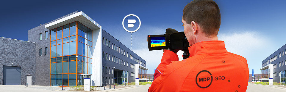
Unlike the energy performance certificate of the building (so-called energy label), professionally processed analysis of thermographic images will show you in what state the building is in terms of heat loss.
Expertly evaluated thermographic measurement is an important basis for the project of building insulation and identification of structural deficiencies of buildings and technologies.
We use thermography for the preparation of energy audits and for quality control of the work performed during the thermal insulation of buildings.
Our consultants will advise you on the most effective way to significantly reduce your heat, gas or electricity costs.
We use a top thermal imaging camera that allows a detailed view of the distribution of the temperature field on the surface of the object of interest. For example, to control the quality of heat saving.
- Do you know the state of construction of your property?
- Do you want to identify "thermal bridges" where heat escapes?
- Do you need to check the newly insulated building? INQUIRY
- Do you know the state of heat distribution, heating elements, production technologies? INQUIRY
- Do you need to check the functionality of solar PV panels?
-


