Waterworks Management

Technology
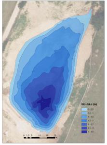
A vessel, a sonar (measuring sensor) and a precision positioning device are needed to map the water bottom. Sensor position and depth are measured during navigation. After evaluating the measured data, a digital model of the level below the water surface is created. Results are typically presented using isolines (contours) or cross sections at the desired scale.
The measurement accuracy is 0.1 % of the measured depth with a resolution of 1 cm.
Applications
- Locating obstacles and objects in the profiles of rivers and waterways, in reservoirs
- Changes in watercourse profiles before and after floods
- Evaluation of the volume of extracted sediments
- Comparison of reservoir profiles before and after rehabilitationLong-term monitoring of water structures
- Sediments deposition
Outputs serve to:
- Increase the reliability and safety of water transport
- Verify the retention capacity of reservoirs
- Verify invoiced costs for sludge removal
